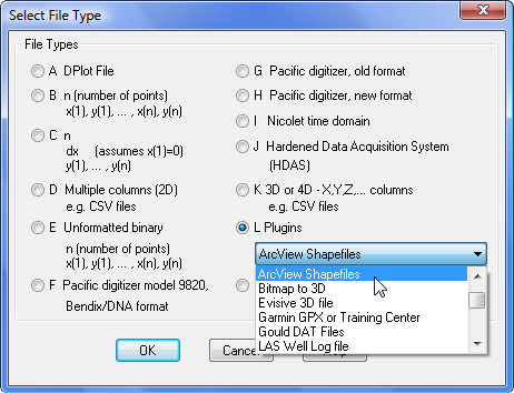
Mercator ProjectionThe Mercator projection is a cylindrical map projection developed by Gerardus Mercator in 1569. It became the standard map projection for nautical purposes because of its ability to represent lines of constant true bearing as straight line segments. While the direction and shapes are accurate on a Mercator projection, it distorts the size. North-south stretching becomes increasingly pronounced with increasing distance from the equator. A Mercator map can never fully show the polar areas, since linear scale becomes infinitely high at the poles. In DPlot input values for this scaling are limited to -360 < x < 360 and -85 < y < 85, where x is longitude in degrees and y is latitude in degrees. Although any number format may be used with this scaling, it is designed for Degrees, Minutes or Degrees, Minutes, Seconds and has no practical value for other formats. DPlot will automatically amend either the width or height of the plot such that the correct scaling is used. It will make this change, if necessary, regardless of whether the Specify size option of the Extents/Intervals/Size command is used. For predictable results with this scale type, use Extents/Intervals/Size, check the Specify size option and enter the desired width and height of the plot, then click the Set X:Y=1:1 button. Although DPlot will display longitudes as expected (-200° is displayed as 160°, for example), on input the data will be drawn with decreasing x values (longitudes) to increasing x values from left to right. Therefore if your map crosses longitude 180° and your input longitudes are positive in the Eastern hemisphere, negative in the Western hemisphere (as is standard practice), you will need to modify the longitudes for the map to be drawn correctly. This is easily done with the Operate on X command on the Edit menu with, for example, X=IF(X>0,X-360,X). Data SourcesThe US Census Bureau has ArcView Shapefile files for US states and counties. ArcView Shapefiles may be read directly into DPlot with the ArcView Shapefile import plugin: 
The Shapefile plugin became available with the licensed copy of DPlot 2.1.5. Licensed users who have purchased DPlot within the last 2 years should sign up for the mailing list to receive instructions for downloading the free upgrade. This plugin expects to find both a .SHP main file and .SHX index file with the same filename in the same directory. The plugin will automatically set Degrees, Minutes number formats for both the X and Y axes, insert nonsense Y=100 points between land masses, and set the scaling to Mercator projection, which in turn forces the Amplitude Limits setting on with limits of +/- 85 degrees (so that those previous nonsense points are ignored, and separate land masses will be drawn separately). A map of the continental United States in compressed DPlot format is available here (~1 Mb). This graph was built from
the Census Bureau files mentioned above, and includes the 48 continental states plus the District of Columbia, stored in alphabetical order. Each state is a
separate "curve" with the (hidden) legend entry corresponding to the state name. (To "unhide" the legend select Text>Legend/Labels and
uncheck "Hide legend".) This file might be useful for plotting state-by-state differences in voting, population density, crime statistics,
etc. In particular this map and others like it may be useful for programmers. For example the DPlot macro/DDE command:
Shapefiles for various countries and the world are available from the DIVA GIS web site and many other sources. |
RUNS ON
Windows 10, Windows 8, Windows 7, 2008, Vista, XP, NT, ME, 2003, 2000, Windows 98, 95 |